FORTAG and Frog Pond. 2: History of Frog Pond
(See also: Main FORTAG Frog Pond Page)
History of Frog Pond
(Based both on original research (F. Watson) and 1994 historical summary by MPRPD.)
- Summary of elements of history most relevant to FORTAG:
(see timeline for details of all documents)
- There has been a long-standing goal to establish regionally-connected hiking, biking, and equestrian trails in the Frog Pond area.
(See 1971 and 1984 Board-approved Monterey County Recreational Trails Plans, 1992 Parklands Group proposal, 1996/7 Fort Ord Reuse Plan, 2016 FORA Draft Trails Concept, and 2016 voter approval of Measure X)
- There has been long-standing desire specifically to establish and re-establish connectivity between the western and eastern portions of the Frog Pond area for wildlife (e.g. California Tiger Salamander), hydrology, and wheelchair-standard public access - specifically through land acquisitions, trails, a trailhead, and a tunnel.
(see ~1991 MPRPD application for surplus federal land, 1992 Parklands Group proposal, 1994 FPWP draft plan, ~1996 litigation, 1998 MPRPD letter to Presidio/FORA, 1999 litigation settlement agreement, 2004/5 MOA between DRO/FORA/developer, 2005 USFWS Biological Opinion, 2006 deed for developable portions of DRO)
- There has been long-standing recognition that the Frog Pond area is inaccessible to wheelchairs and should be made accessible.
(see 1994 FPWP draft plan, 1998 MPRPD letter to Presidio/FORA, 1998 Master Plan)
- There has been a long-term pattern of dramatic change in the Frog Pond landscape - from marsh, to grassland, to riparian forest - and a recognition that natural functioning involves periodic changes in habitat.
(see 1941 aerial photo, 1969 photo, 1994 FPWP draft plan, and 2002 Balance/Zander plan)
- There has been a long-standing desire to protect nature at Frog Pond.
(See 1977 acquisition of western parcel, 1975 Army report and numerous subsequent documents on CNPS reserves, 1994 FPWP draft plan, and 2002 Balance/Zander plan.)
- There has been long-standing public-health concern about mosquito breeding at Frog Pond and access necessary to eliminate mosquitoes
(See 1988, 1994, and 2003 letters between NSVMAD and MPRPD, and 1994 FPWP draft plan.)
- There has been some plasticity in the management of the Frog Pond area. For example, an ordinance once prohibitted dogs, but dogs are now common and signage implies that they are allowed.
(See 1994 FPWP draft plan, and recent signage.)
- FORTAG proponents have conducted extensive outreach and project discussion with all stakeholders
(Meetings & site visitswith MPRPD officials on 19 occasions between 2014 and 2019.
Meetings & site visits with City of DRO officials on 21 occasions between 2014 and 2019.
Meetings & site visits with city residents, developers, CalTrans, FORA, Audubon, CNPS, CDFW, USFWS, ...)
- There has been a long-standing goal to establish regionally-connected hiking, biking, and equestrian trails in the Frog Pond area.
- Detailed timeline:
- 1862. Probable commencement of cattle grazing at Frog Pond after patent granted for Rancho Noche Buena.
- 1918. Ownership by David Jacks corporation
- 1920. Ownership by C.A.Ryan
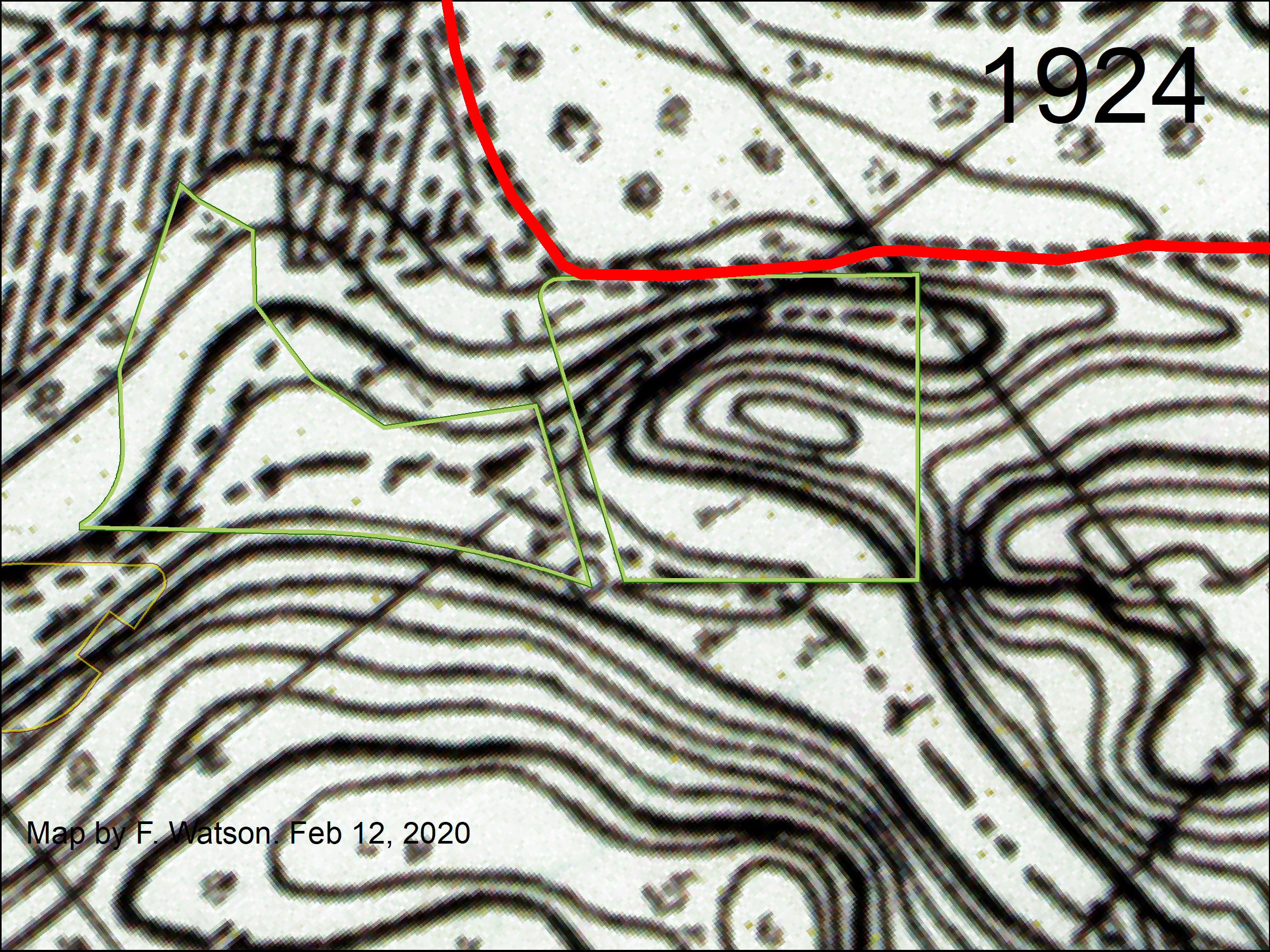
- 1924. Historical map suggests that the earthen fill separating the western and eastern portions of the Frog Pond area was not yet emplaced. North-South Road did not yet extend south to Canyon Del Rey Boulevard (probably because of the steep terrain at Frog Pond), but instead turned east at South Boundary Road.
- 1927. Ownership by Lou Ryan
- 1929. Historical map suggests earthen fill between western and eastern Frog Pond areas not yet emplaced.
- 1933. Historical map suggests North-South Road may have been extended south to Canyon Del Rey Boulevard by this date. So, our best estimate of the date of emplacement of the earthen fill is sometime between 1929 and 1933.
- 19??. Ownership by T.A. Work
- 19??. Spring water bottling works in northwestern portion of western parcel
- 19??. Coast redwoods planted in northwestern portion of western parcel
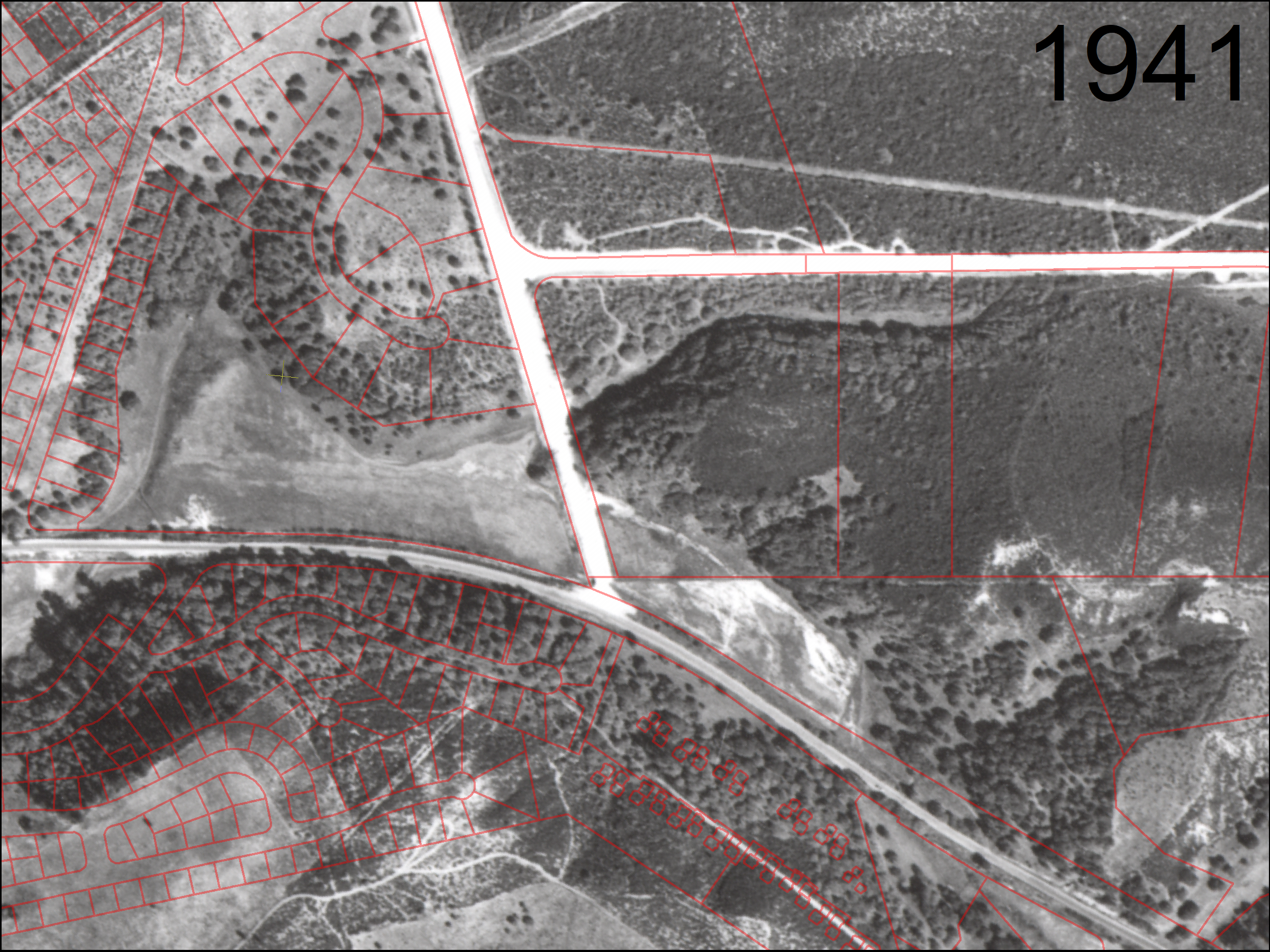
- In 1941, the flood plain now known as Frog Pond was grassy and generally devoid of trees. The upland areas were oak woodland and grassland. The grove of coast redwoods may have been recently planted. The eastern portions supported maritime chaparral.
Frog Pond in 1941 (click to enlarge):
Since 1941, the grassy lowland has since been replaced by dense willow forest. The upland oak woodland is largely intact, but heavily invaded in places by non-native iceplant and ivy. Non-native acacia trees tower above the willows in several areas.
Since 1941, in the eastern parcel, the balance between maritime chaparral and oak woodland has shifted. Some areas of maritime chaparral have transitioned to oak woodland.
In 1941, North-South Road had recently been constructed across the flood plain on a causeway of earthen fill.
In 1941, Arroyo Del Rey had already been ditched to run directly adjacent to Canyon Del Rey Boulevard, and apparently diked to reduce flooding. The previous course of the creek is barely discernable as a few meanders visible in the grassy floodplain. Prior to grazing, it may not have been a creek, so much as an arangement of swales in an otherwise diffuse marshy area.
- 1953. Incorporation of the City of Del Rey Oaks.
- 1950s. Annexation of additional land into City of Del Rey Oaks. Donation of park land by T.A. Work.
- 1956-1961. Period in which the the "Dust Trail" system was built. This system centers on a trail connection running along the Fort Ord boundary ridge for 1.75 miles between North-South Road and York Rd. The system includes loops and spurs, mainly at the western end, overlapping the eastern MPRPD parcels. We learned the name "Dust Trail" from the York School cross-country team. We inferred the period of construction from the difference between 1956 and 1961 aerial imagery.
- 1959. Canyon Del Rey Boulevard transferred from county to state - thus becoming Highway 218.
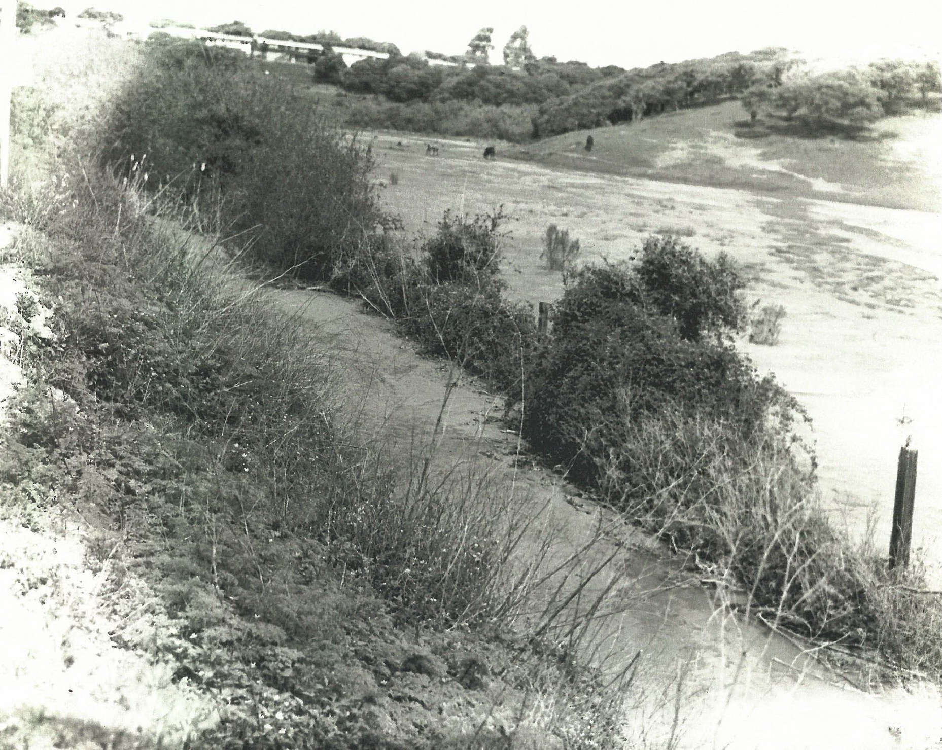
- In 1969, the flood plain was still grassy and grazed by cattle. Fence posts demarcate the parcel boundary. The posts are still in place (December 2019) and the boundary is now between CalTrans (south) and MPRPD (north). Houses are visible along Carlton Drive, constructed sometime between 1941 and 1969.
April 14, 1969 - lookwing northwest from Canyon Del Rey Boulevard
(click to enlarge):
- 1970. Utah Development Company proposed 175-unit townhouse development for western parcel. Opposition emerged.
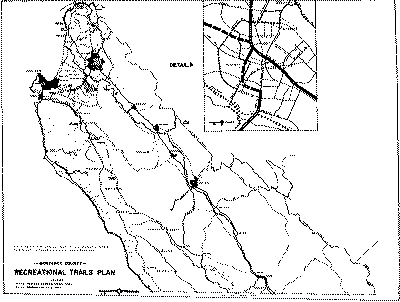
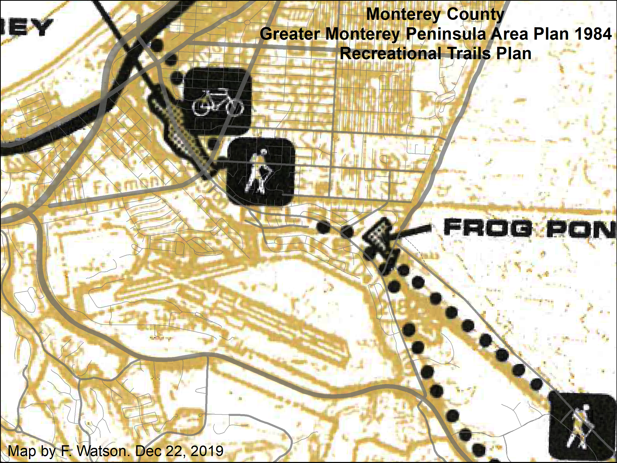
- 1971, March 30. "Monterey County Recreational Trails Plan" adopted by Monterey County Board of Supervisors. Includes a map showing a "Proposed Riding and Hiking Trail" trail reaching Frog Pond from the east, generally near where the "Dust Trail" now runs along the northern edge of Ryan Ranch, and a "Proposed Bicycle Trail" along Highway 218 and Highway 68.
- 1971. Aerial imagery indicates minimal evidence of recent grazing, and four or five small willow (?) trees in the western corner of the flood plain portion of the western parcel.
- 1972. MPRPD formed.
- 1974. Failed DRO bond measure to purchase western parcel.
- 1975. First documetation of the eventual California Native Plant Society (CNPS) Native Plant Reserve system on Fort Ord. "Fort Ord Natural Resources Program" report by Army. Describes the reserve system (9 reserves). Includes maps. States that “Plans are underway to establish a trail system in Reserve 1”
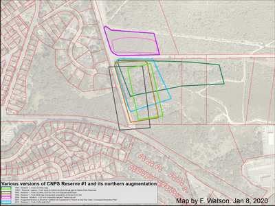
The precise boundaries of Reserve #1 are uncertain. The following map overlays five different depections of Reserve #1, along with two different depictions of the 1998 northern augmentation.
- 1976, July. Article on CNPS Fort Ord reserves published in Fremontia.
Griffin, James. Native Plant Reserves at Fort Ord. Fremontia 4(2):25-28.
“a series of small tracts are given administrative protection as native plant reserves by the U.S. Army. As long as there is no overriding military need for these small tracts, they will be preserved.”
“The prime mover in establishing these reserves was CNPS Fellow Beatrice Howitt. Early in 1967 she encouraged Fort Ord's Commanding Officer, General Robert G. Fergusson, to set aside some "protected areas." Although these reserves are not yet clearly marked in the field, they have been firmly established in master plans of the Post Engineer and are currently designated as areas "1" to "9" on official maps.”
- 1977, June. "Monterey County
Master Drainage Plan -
Canyon Del Rey Watershed
Drainage and Erosion", 76 page report. Describes channels and culverts near "Frog Pond". Recommends that a mitigation measure "should":
"Design the Del Rey Oaks "Frog Pond" as a sediment catch basin for large floods. This would require permanent dedication of this area for wetland, design of spillway at the highway 218 crossing, and provision of access to
remove accumulated sediment. It is estimated that the 10-acre area will have a maximum of about 100 acre-feet of storage and a trap efficiency of about 85% (Bnme 1953)."
(100 acre-feet over 10 acres is equivalent to 10 feet of depth)
- 1977, December. MPRPD purchased western parcel for $125,000, half-funded by a federal Land and Water Conservation Fund grant.
- 1978. Western parcel annexed into DRO city limits
(formely in unincorporated County limits). Zoned as open space. Community advisory group formed. Interpretive brochures published by CNPS & Lee Dittman (naturalist consultant for MPRPD).
- After 1977. Grazing ceased. Grassland transitioned to willow forest. Trails, boardwalk, and interpretive markers installed.
- 1978. Aerial imagery indicates patchy cover of willow trees cover about 60% of the flood plain portion of the western parcel.
- 1979. Stairway constructed from Canyon Del Rey Boulevard down into western parcel. Boardwalk constructed across pond (removed 1993). Network of perimeter trails constructed (reduced in 1993). 24 interpretive sign posts installed (removed 1993).
- 1980, October 8. Formation of Canyon del Rey Watershed Joint Powers Agency to "coordinate the development and maintenance of the Canyon Del Rey Watershed so as to preserve and improve the water quality of Laguna Grande and Roberts Lakes for the use and benefit of the citizens of the region". Members: MPRPD, Monterey County, Cities of Seaside, Monterey, and Del Rey Oaks.
- 1980, Oct 14. Map of CNPS Fort Ord reserve numbers 1 to 10
- 1981, March 12. Annotated list of birds observed in or from the Frog Pond Natural Area. L. Dittman.
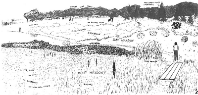
- 1982, June. Booklet: "The Frog Pond Interpretive Trail - Being a Guide to Understanding the Life of the Frog Pond Natural Area", by Lee Dittman.
Includes map showing two parking locations on the opposite side of Highway 218, andfour trails that no longer exist (Tanglewood Trail, Marsh Trail, the cutoff in the western corner, and the access trail to the southern corner).

Also includes an illustration depicting a much more open floodplain habitat ("meadow", "rushes", "nettles") in an area that is now (Jan 2020) dense arroyo willow.
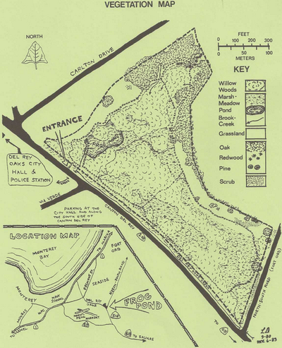
- 1983, June 18. Plants of the Frog Pond Natural Area. Lee Dittman. MPRPD / CNPS. Includes map showing trail system, and four small trails that don't exist anymore (Dec 2019).
- 1983. Griffin, J. R. A partial list of plants on Fort Ord Native Plant Reserve and environs. Monterey Bay Chapter, California Native Plant Soc. 3 pp
Document not obtained yet.
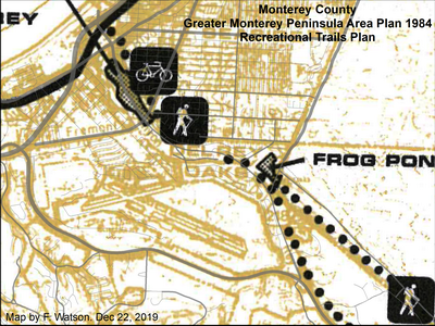
- 1984, Dec. 17. Greater Monterey Peninsula Area Plan adopted by Monterey County Board of Supervisors. Includes Recreational Trails Plan showing planned hiking, biking, and equestrian trails through the Frog Pond area.
- 1987. Aerial imagery indicates willow trees covering most of the western parcel, with two small grassy patches east of the pond.
- 1988. Letter from Northern Salinas Valley Mosquito Abatement District (NSVMAD) to MPRPD expressing concern about mosquito problem at the pond. Pond report to have transitioned from grassland to thickets of willow and bulrush.
- 1998 March. General Plan for City of Del Rey Oaks (subsequently updated in 1997). Document not obtained yet.
- 1989 Nov 20. Army map showing the locations of the CNPS reserves.
- 1989 Dec 12. Letter from CNPS to Army negotiating new reserve locations in relation to Army’s proposed Ammunition Supply Point and associated CEQA actions.
- 1989 Dec 20. Letter from Army to CNPS acknowledging the Dec 12 letter.
This is essentially the earliest document in contemporary (2019) circulation documenting the agreement between Army & CNPS relating to the reserve system on Fort Ord.
- 1990s early. Undated sketch map showing locations of CNPS Fort Ord reserves.
- 1991. Redwood bench contrsucted at eastern end of western parcel. (Not recently located in 2019)
- 1991. Fort Ord closure. MPRPD applied to the federal government to create a "Natural Area Expansion" - i.e. an extension of the existing MPRPD property to include adjacent property in the former Fort Ord on the eastern side of (what was then) North-South Road.
- 1992, Jan. "Fort Ord Parklands - A Vision Statement" produced by the "Parklands Group" of non-profit organizations. Calls for the former Fort Ord areas along side SBR and GJMB to be maintained as a "greenbelt" of "Recreation Lands" providing a "wide range of recreational opportunities to the local community" including a "network of trails" running east-west generally parallel to SBR and north-south generally parallel to what was then North-South Road. Notes potential for expansion of the "Frog Pond Natural Area" as well as "access and parking facilities that may be developable at the Canyon Del Rey entrance to North-South Road."
- 1992 Sep 22. Army map showing the locations of CNPS reserves. Excludes Reserve #1. Shows only background basemap linework at this location.
- 1992 Oct 27. Army report relating to Ammunition Supply Point, includes map of reserves. Includes Reserve #1, but with a substantially different shape to previous maps.
- 1992 circa. Brochure about the reserves; includes a map; produced by Jones & Stokes. Approximate date of interpretative signage posted at each reserve.
- 1992, December. Flora and Fauna Baseline Study of Fort Ord, California. US Army. Describes plant communities of CNPS Reserve #1 (Appendix I). Notes the occurrence of Seaside Bird's Beak "along the perimeter of the reserve". Indicates Bird's Beak location in Figure F-7.
- 1993 June. Army FEIS for Fort Ord Disposal and Reuse. Includes map of the reserves.
- 1993. Removal of boardwalk across pond. Removal of 24 interpretive posts. Reduction of trail network.
- Circa 1993. Refurbishment of southern entrance stairs & sign.
- 1994, Sept. Draft (?) "Frog Pond Wetland Preserve Management Plan" document produced by MPRPD. It appears likely that this plan was never approved.
Some relevant phrases:
"The District's intent is to maintain a healthy environment and haven for wildlife and a safe and educational open space for the community."
"Parking at the Frog Pond is limited."
"Stairs limit access to fully mobile visitors only."
"District ordinance prohibits access to dogs, bicycles, horses. motorized vehicles, cycles, and equipment."
"The combined loss of grazing, hydrological disruption, and unimpeded growth of willows has converted the once open flood basin marsh and grassland into a densely overgrown willow forest. This vegetational succession cannot be construed as natural but rather inevitable given the degree of human influences."
"Public access and use in preserves is secondary to landscape conservation and protection."
"...the lower lying edges of the ponding areas will be bermed"
"...the District's interest in adjacent surplus lands of Fort Ord ... envisions a trail connector to the expansion area south of North-South Road"
"Ponding of water will be further enhanced by the removal of willows in areas of natural water collection. A third element designed to provide more ponding is the diverting of Canyon Del Rey Creek into the Frog pond at the southwest comer of the site."
"The Frog Pond provides good habitat for introduction of California tiger salamanders"
"With the closure and down-sizing of Fort Ord, a unique opportunity exists to increase the Frog Pond's biological diversity, educational potential, and recreational aesthetics. There are currently two applications before the Army regarding land to the south of the Frog Pond. The District's pending application requests approximately 32 acres to the south across North-South Road to be added to the Frog Pond. This area includes the historic extent of the Frog Pond's wetlands and an endangered plant reserve as well (Appendix 3.3.e.1). This application is in conflict with the City of Del Rey Oaks' application which envisions a conference center and health spa complex on 17 of the 32 acres the Park District has applied for (Appendix 3.3.e.2)"
- 1994, Sept. 13. Letter from MPRPD to NSVMAD discusses remediation of stagnant water problem through burning of slashed vegetation and possible re-routing of water from Arroyo Del Rey.
- 1994. First version of Fort Ord Habiat Management Plan.
- 1995 Feb 27. BLM map of proposed acquisitions at Fort Ord. Includes depiction of CNPS reserves.
- 1995 April 19. MOU between BLM and Army re land transfer to BLM, includes that BLM shall honor existing Army agreement with CNPS about reserves.
- 1995? Approximate date of weir installation and berming (referred to in 1994 MPRPD document) (manifested as the DG trail on the southern side?)
- 1996 approx. Litigation between MPRPD, FORA, City of DRO, and or City of Monterey - existence implied by subsequent settlement documents.
- 1996/7. Fort Ord Reuse Plan. Notes that the parcels east of GJMB are intended as "augmentation of the Frog Pond area". Notes relating to development parcels immediately east of the eastern Frog Pond parcels: stormwater prohibition, fuel break required, use limited to trailhead etc.
- 1997 January. General Plan Update for the City of Del Rey Oaks.
- 1997 approx. Army creates a system of reuse "parcels" for the former Fort Ord, identified by a capital letter and a number - e.g. "E29" - often followed by a lower-case letter and some decimal numbers as the parcels are sub-divided over time - e.g. "E29a.1". These parcels are similar to, but rarely exactly the same as the eventually deeded legal parcel boundaries, nor are they the same as the parcels indicated on the county GIS layer.
- 1997, Jan 24. Memorandum discussing agreement points relating to conflict between desired land uses for former Fort Ord near frog Pond - MPRPD, City of Del Rey Oaks, & City of Monterey.
- 1997, May 1. Additional memorandum following from the 1997-May-1 memo.
- 1997. Revised (now final) version of Fort Ord Habiat Management Plan.
- 1997, Aug 13. Letter from FORA to Army requesting clarification of the right-of-way (ROW) along North-South Road between the western and eastern portions of the Frog Pond area. Document not obtained yet.
- 1997, Aug 14. Letter from Army to City of DRO explaining that ROW as specified in the HMP is 85-ft and that this was based on the signed location of CNPS Reserve #1. Indicates ROW could be subsequently negotiable between DRO, FORA, County, MPRPD, USFWS, & CNPS.
- 1997, Aug 28. Letter from Army to FORA explaining issues relating to North-South Road ROW. Disagrees with points made in FORA's Aug 13 letter. Indicates entire HMP cannot be changed to modify ROW but that ROW-modification specifically could be subsequently negotiated among parties including DOI, USFWS, & CNPS.
- 1997, Sept. (and 1998 & 1999) Zander biological survey's of FORA NSR/Hwy218 widening project area. Cited in take application (2000). Documents perhaps not yet obtained.
- 1998, Feb 10. Letter to CNPS from mayor of DRO, endorsing the notion that 2 acres of future DRO development land north of SBR could used to mitigate impacts of NSR widening on CNPS Reserve #1.
- 1998, April 6. MPRPD Master Plan includes Frog Pond on the front cover, includes the eastern parcels in the concept of what is Frog Pond ("22 acre public benefit conveyance"). Notes the intent to pursue accessibility improvements specifically at Frog Pond and in preserves in general.
- 1998, April 8 & 9. Letters from FORA to Army/Presidio of Monterey summarizing board-approved conflict resolutions relating to habitat mangement near NSR & SBR, and requesting concurrence.
- 1998 April 22. Agreement between CNPS, DRO, and FORA in relation to FORA’s project to widen North South Road (now General Jim Moore Blvd). States that 2 additional acres will be preserved on NE corner of NSR and SBR to compensate for loss of habitat due to road widening. Signed by all parties.
(Subsequently modified June 1999)
- 1998, Dec. 4. Letter from MPRPD attorney to Presidio of Monterey in relation to the EA/IS for FORA's "North-South Road/Highway 218 Improvement Project". Raises concerns about:
- Road project encroachment into MPRPD property
- "Transportation Safety - No safe access to trail on Park District properties on either side of North-South Road. The FORA plan calls for use of the proposed parking lot to the east of the District Frog Pond property as a trailhead parking lot for persons who wish lo go from east to west on the District property, across North-South Road. There is an existing trail which connects the two properties, crossing North-South Road about 300 feet from its intersection with Route 218. Presently, there is little enough traffic on North-South Road. so that crossing the road causes no safety problem. With an expected ADT of 8200 trips per day on this main access to. CSUMB and to Laguna Seca, however, the trail access becomes a real safety issue.."
"The District requests a redesign of the plan to provide for improvements which would provide access at the trail crossing, preferably by means of a below-grade level tunnel. An above the road walkway would not allow for use of the crossing by the disabled."
- 1998, Dec 4. Letter from CNPS to FORA in relation to the EA/IS for FORA's "North-South Road/Highway 218 Improvement Project". Requests additional & clarified language in the EA/IS.
- 1998, Dec 22. Amendment to EA/IS for North-South Road/Highway 218 project. Includes response to comments (see above) and revised text.
- 1999, March 24. Letter from EMC Planning to FORA relating to potential for Seaside Bird's Beak and other rare plants to occur in FORA's NSR/Hwy218 project site. Concludes no consultation with CDFG is necessary because prior documentation of SBB was only on west side of NSR, and road widening is proposed for east side. (Note: Subsequent surveys (e.g. Zander 2004) found SBB on east side of NSR.)
- 1999, April. (essentially the same as 1998, Dec 22) Response by FORA / Presidio to MPRPD attorney's 1998-Dec-4 letter:
"During the lengthy development of the plans for this project, FORA evaluated the probable costs associated with the development of a ''below-grade level tunnel." Ownership of any such sub-grade structure would belong to the jurisdiction that assumes ownership of the roadway. High costs, combined with police department and other safety concerns associated with such a structure made it an undesirable, and ultimately infeasible option.
Due to the existing grades at either side of North-South Road, Americans with Disabilities Act (ADA) access is not possible at a point 300 feet north of SR 218 on North-South Road. A pedestrian crosswalk (at road station 4+60) with pedestrian warning signs for north and southbound traffic on North-South Road and ADA curb ramps will provide both pedestrian safety and ADA access at the proposed point of crossing."
- 1999, June 23 - Aug. 24. Modification of April 1998 CNPS agreement.
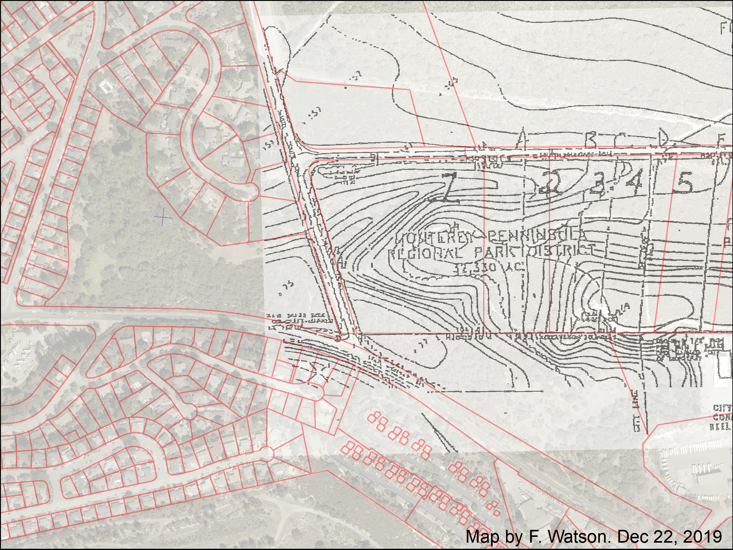
- 1999, May 12. Fully executed "Boundary Conflict Resolution Agreement" between MPRPD, FORA, City of Del Rey Oaks, & City of Monterey.
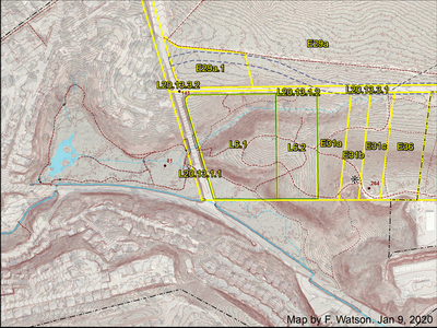
Divides area east of GJMB into 5 sections (see map below).
"The Monterey Peninsula Reglonal Park District will secure peliTlits, pay for and construct an interim access road from South Boundary Road ta an interim parking lot for public use within Parcel 4."
"The direct discharge of storm water or other drainage from new impervious surfaces created by development of the office park (OP) parcel into the ephemeral drainage in the natural area expansion (NAE.) parcel will be prohibited. No increase in the rate of flow of STORMWATER runoff beyond pre-development background levels will be allowed"
Section / parcel descriptions:
1. "Approximately 20.14 acres ... shall be designated as a Natural Area Expansion (NAE) parcel, title to which shall be traosferred to the Monterey Peninsula Regional Park District for use as a visitar-serving, natural open space parkland adjunct to the District's existing Frogpond area"
2. "An approximately 240 ft. wide Primary Buffer Zone, comprising some 5 acres ... Allowable uses Within the Primary Buffer Zone may be limited to, picnic areas, trailheads, interpretive signage, drainage facilities, City of Del Rey Oaks or Park District parking . No buildings or roadways shall be allowed in the Primary Buffer Zone."
3. "An approximately 150 ft. wide Secondary Buffer Zone, ... comprising some 3.13 acres immediately southeast of parallel to the to the Primary Buffer Zone (Parcel 2) shall be established ... Allowable uses within the Secondary Buffer Zone may be limited to all uses allowed in the Primary Buffer Zone plus roads, parking, and buildings sited to minimize impact on the adjacent park lands."
4 & 5. Office Park.
Map from 1999 agreement, overlaid with 2019 parcel boundaries:
(actually, the parcel boundaries near Sections 1 & 2 are incorrect in the county GIS layer shown here (red); see maps later in this page for correct (green) parcel boundaries),

- 2000, May 11. FORA application to CDFG for incidental take authorization for Seaside Bird's Beak as part of NSR/Hwy218 widening project. Includes Mitigation Plan prepared by Zander (April 2000). Maps locations of Seaside's Birds Beak that would be impacted by project. Proposes mitigation by establishing new colonies on Range 42 (south of Eucalyptus Rd about half a mile west of old BLM HQ). (Note: It is almost certain CDFG never authorized this take, as evidenced by the fact the project never extended as far north as the SBB area, and by subsequent emails referencing CDFGs action around this time. An April 20 memo from Zander to FORA foreshadows the possibility that CDFG might not accept the proposed mitigation plan. It is not inconceivable that the application was never submitted, although the transmittal letter is signed by the FORA Assistant EO at the time.)
- 2002, Feb. "Draft Interim Plan Habitat Protection and Enhancement - Frog Pond Wetland Preserve" prepared by Balance Hydrologics & Zander Associates. Detailed investigation of the potential for sedimentation to adversely impact the natural function of the western parcel.
- 2002, July. Redevelopment plan - Del Rey Oaks Fort Ord Redevelopment Project. (adopted 2003, July 22; deemed consistent by FORA 2003, Sep. 17)
- 2003 June. Army issues Draft Finding of Suitability for Early Transfer (FOSET) for DRO land in former Fort Ord. (See also: Final FOSET July 2004)
- 2003, Aug. 25. Letter from NSVMAD to MPRPD proposed construction of two 10-ft vehicle access roads through middle of western parcel.
- 2003 Sep. 22. Letter from MPRPD to NSVMAD indicates MPRPD intends to collaborate on the "access clearing" requested a few weeks earlier. Also reports that MPRPD hopes to have a long-range management plan approved by Spring 2004. This perhaps implies that the 1994 "Management Plan" was never approved?
- 2004. Zander finds endangered Seaside Bird's-beak at GJMB/SBR intersection as part of what became 2005 EA/IS for GJMB/Eucalyptus Rd.
- 2004, Feb 8. Memo from DRO developer "Federal Development" to parties involved in FORA/DRO development. Seeks modification of what eventually became July 2004 FOSET (see below) in relation to size of CNPS habitat parcel.
- 2004, July. Army issues Finding of Suitability for Early Transfer (FOSET) that covers Parcel E29a (DRO north of SBR) except for a 4.63 acre habitat reserve parcel in the general area identified in the 1998 CNPS/DRO/FORA agreement: "Included within Parcel E29a is an approximately 5-acre habitat reserve area that is not included in this transfer." (See also: ROD October 2008)
- 2005, March 14 . Biological Opinion by USFWS in releation to reuse of former Fort Ord. Includes a focus on maximizing opportunity for use of Frog Pond area by California Tiger Salamanders. Resulted in Memorandum of Agreement with City of Del Rey Oaks restricting hydrologic impacts by the city's developments on habitat downstream in Frog Pond area.
- 2005. Army deeds DRO developable land to FORA. The 4.63 acre habitat reserve parcel is identified in but excluded from this deed as "Exception Parcel B" and described by the surveyor as "Excepting also therefrom the following described parcel of land for habitat preserve purposes"
- 2006, March 7. FORA deeds developable DRO land to DRO. The 4.63 acre habitat reserve north of SBR is "excepted" and described. Prohibits runoff to Frog Pond area: "The direct discharge of stormwater or other drainage from new impervious surfaces created by development on Parcels 31a-c into the ephemeral drainage in the Natural Area Expansion is prohibited. No increase in the rate of flow of stormwater runoff beyond predevelopment levels will be allowed."
- 2007 March. Draft Residential Use Prohibition. Appendix E of DRO MRA study by MACTEC for Army.
- 2007, April 12th. Land survey map for eastern parcels recorded by county (13.27 ac and 6.90 ac).
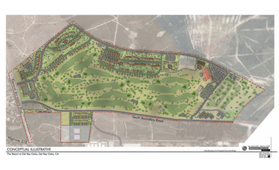
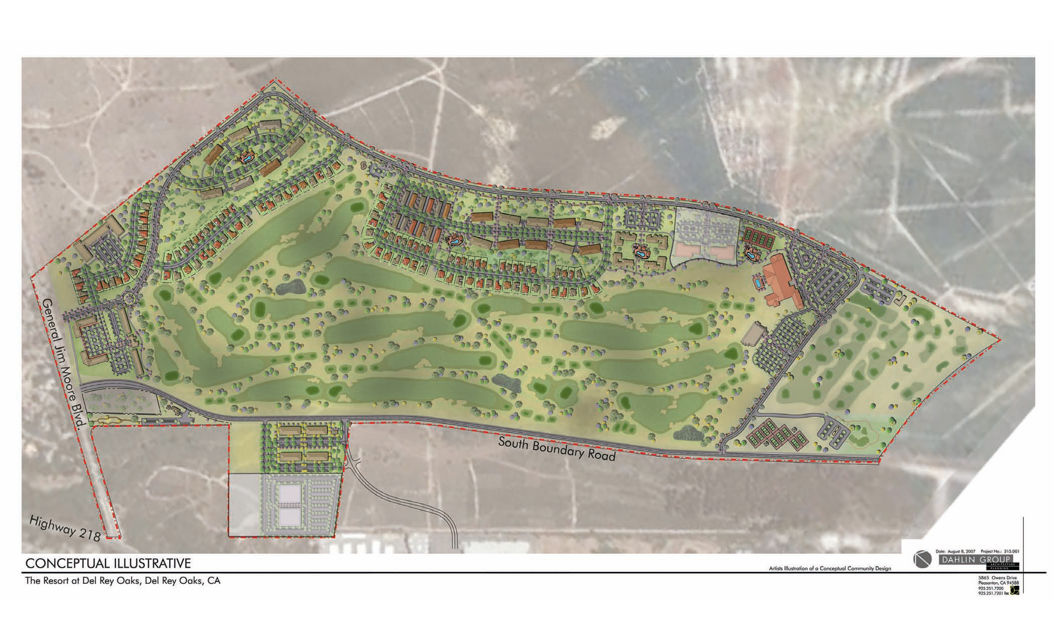
- 2007, Aug. 8. Illustrative plan for the Resort at Del Rey Oaks.
- 2007 November (need to check). FORA public meeting announcing the closure of "ESCA" parcels for munitions work - including the eastern-most of the two eastern MPRPD parcels.
- 2008, Jan. 10. Notice of Preparation of DEIR for "Resort at Del Rey Oaks".
(Note: DEIR never completed (?) but biological surveys were completed by DD&A)
- 2008, Feb. 19. "Final South Boundary Road Biological Monitoring Report Former Fort Ord". Prepared for USACE by Burleson Consulting Inc. Reports on biological survey in relation to the clearing of a 200 ft fuel break immediately north of South Boundary Road.
- 2009, March 18. "Residential Protocol" by DTSC - relates to development constraints on Del Rey Oaks Lands.
- 2008-2009. Main period of activity planning the golf-themed "Resort at Del Rey Oaks".
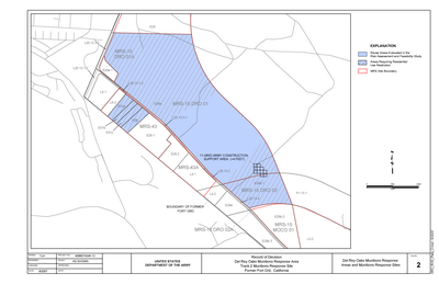
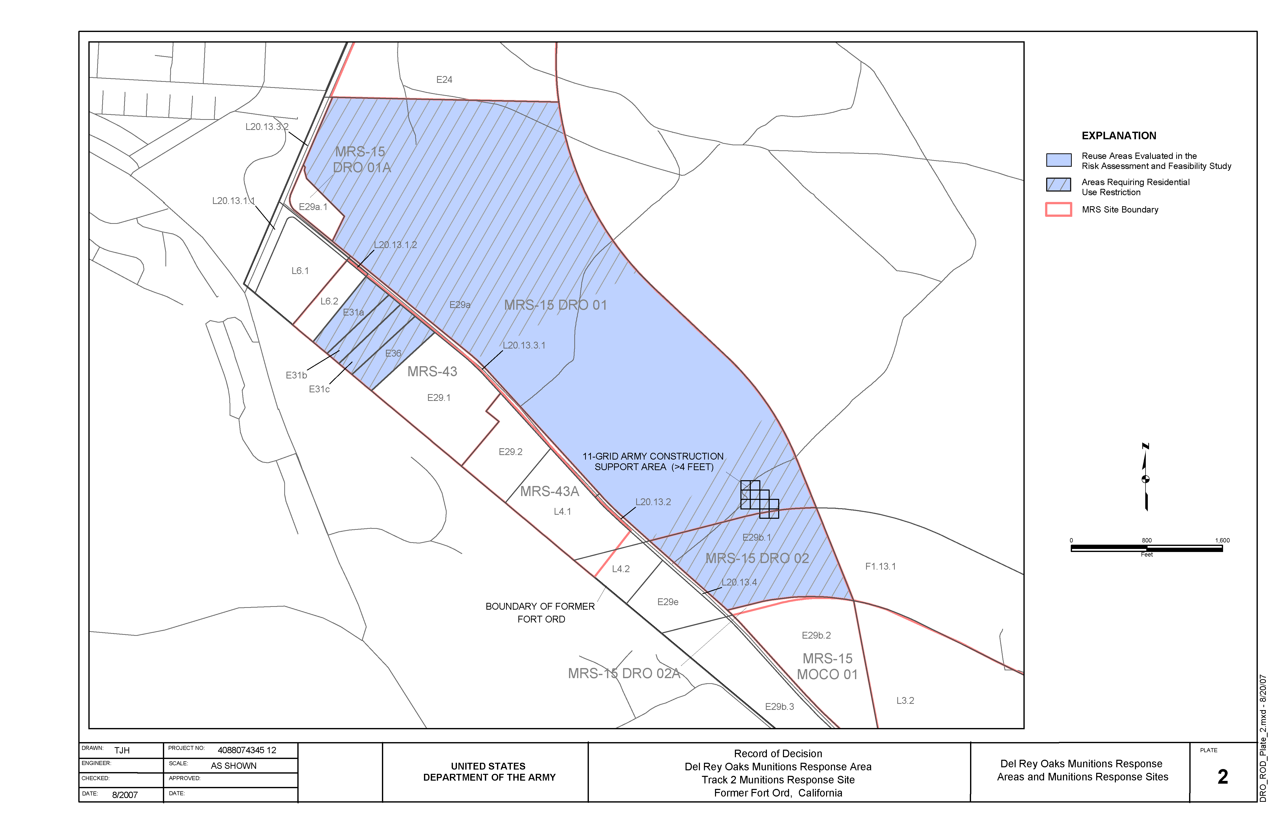
- 2008, Oct. 6. US Army: Record of Decision Del Rey Oaks Munitions Response Area Track 2 Munitions Response Site. Indicates areas where residential use restrictions exist on the DRO portions of former Fort Ord zoned for development. See also: FOSET July 2004.
- 2008, Nov. 25. "Frog Pond Wetlands Enhancement Plan - Scope of Work" by MPRPD. Includes the "17 acre" western parcel, and the "20 acre" eastern additions.
- 2009, July 10. Deed for 13.27 acre eastern parcel recorded by county, from Army to FORA. Map in deed approximately matches the 1999 settlement agreement. Secondary data do not match deed and are thus inferred as inaccurate, including: county parcel GIS data and Army parcel GIS data. The total 20.19 acres east of GJMB is split into 13.27 western acres deeded in 2009, and 6.90 eastern acres yet to be deeded to MPRPD. The reason for the split is probably because the eastern 6.90 acres were identified for further munitions attention as part of the ESCA process (still ongoing in Dec. 2019).
- 2009, July 10. Deed for CNPS habitat parcel recorded by county. (From Army to DRO)
- 2009, Oct. 1. Possible date of deed for 13.27 acre eastern parcel moving from FORA to MPRPD.
- 2010, May. SBR EA/IS mentions and maps a 2.25 acre "Habitat area" north of SBR.
- 2010 (Nov) FORA applies for Seaside Bird's-beak Take Permit, designating the 4.63 acre habitat reserve parcel as mitigation. Mistakenly refers to it as: "4.65 acres" (should be 4.63), and has a typo in the APN "0311-191-0113-000" (should be 031-191-013-000). Permit never issued. Project never happened.
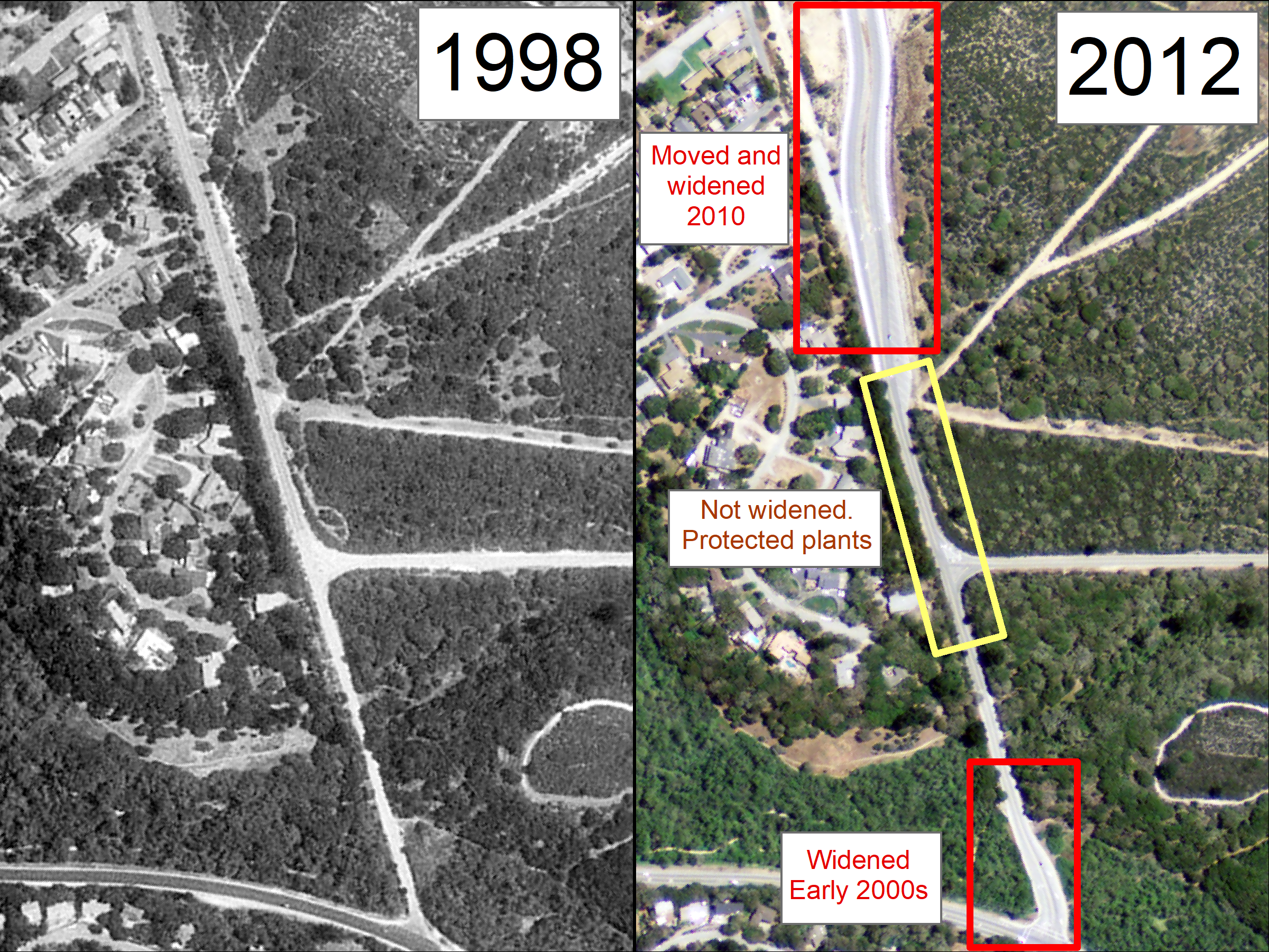
- General Jim Moore Boulevard was constructed in 2010. The portion near the South Boundary Road intersection was never widened. Protected plants grow there (Seasde Bird's-beak).
- 2012 Jan. The Wallflower (CNPS magazine). Includes brief summary of CNPS reserves on Fort Ord; anonymous, but probably by David Styer & Bruce Delgado, who are listed as giving a talk on this topic. Notes that 9 reserves were set aside soon after 1966, in an informal agreement between CNPS and Army.
- 2012 April 20. Fort Ord National Monument proclaimed by President Barack Obama.
- 2012, July 26. City of Monterey Request for Qualifications (RFQ) for development of city's Fort Ord lands
- 2014, April 1. First FORTAG meeting with MPRPD staff about Frog Pond and other MPRPD opportunities on former Fort Ord. Fred, Watson, Scott Waltz, Tim Jensen.
- 2014, April. "Canyon del Rey Master
Drainage Plan - Draft" prepared by Balance Hydrologics for MPWMD. Describes hydrology & hydraulics of the watersheds above Frog Pond, and of the Arroyo del Rey channel and culverts adjacent to Frog Pond.
- 2014, June 30. FORTAG meeting with MPRPD staff about Frog Pond and other MPRPD opportunities on former Fort Ord. Fred, Watson, Scott Waltz, Rafael Payan.
- 2014, July 7. Public presentation about FORTAG to MPRPD Board of Directors.
- 2014, Sept. Possible date when DRO sold land to Monterey Peninsula Properties just north of the 4.63 acre habitat reserve.
- 2014, Sep. 5. FORTAG tour for MPRPD board members and staff. Scott Waltz, Fred Watson, Christine Moss, Tim Jensen, Caine Camarillo, Jackie Nelson.
- 2014, Sep. 12.
FORTAG tour for MPRPD board members and staff. Scott Waltz, Fred Watson, Kathleen Lee, Kelly Sorenson, Rafael Payan.
- 2014, Oct. 3. FORTAG tour for MPRPD board member. Scott Waltz, Fred Watson, John Dalessio.
- 2014, Oct 9. FORTAG meeting with DRO city manager & future private developers. Scott Waltz, Fred Watson, Dan Dawson, Sean Kranyak, Brad Slama.
- 2014, Nov 18. FORTAG meeting with MPRPD staff. Scott Waltz, Fred Watson, Tim Jensen.
- 2015, Feb 2. Frog Pond Wetland Preserve Enhancement and Erosion Control Plan. CSUMB report for MPRPD by Geisler, Smith, & Watson.
- 2015, April 10. FORTAG meeting with DRO city manager. Scott Waltz, Fred Watson, Dan Dawson
- 2015, April 14. FORTAG meeting with MPRPD Board Chair. Scott Waltz, Fred Watson, Bruce Delgado, Kelly Sorenson.
- 2015, April 16. FORTAG tour with future MPRPD Board member. Scott Waltz, Fred Watson, Katie Pofahl.
- 2015, April 21. FORTAG meeting with DRO developers. Scott Waltz, Fred Watson, Sean Kranyak, Brad Slama.
- 2015, April 25. FORTAG discussed by MPRPD directors at all-day Strategic Planning Study Session.
- 2015, Aug. 26. MPRPD spoke and wrote in support of FORTAG at TAMC Board meeting.
- 2015, Sep. 18. FORTAG meeting including MPRPD manager. Scott Waltz, Fred Watson, Debbie Hale, Rafael Payan, Josh Metz (via phone), Jonathan Garcia, Ted Lopez, Virginia Murillo, Todd Muck.
- 2015, Sep. 25. FORTAG phone meeting with CalTrans staff. Scott Waltz, Fred Watson, Brandy Rider & other Caltrans staff.
- 2015, Oct. 7. Fort Ord site visit with MPRPD staff. Scott Waltz, Fred Watson, Tim Jensen, Caine Camarillo.
- 2015, Oct 23. FORTAG meeting with CNPS representative about CNPS Reserve #1. Scott Waltz, Fred Watson, Brian LeNeve.
- 2015, Nov 15. CSUMB graduate class project for City of DRO: "Stormwater mapping and land use analysis, City of Del Rey Oaks, California". Includes some information on stormwater draining to Frog Pond (Fig. 3).
- 2016, Feb 19. FORTAG meeting with DRO mayor. Scott Waltz, Fred Watson, Jerry Edelen.
- 2016, March. CNPS Board passed following motion:
Monterey Bay CNPS supports the general concept of a trail through Plant Preserve 1. The Chapter would need to prevent negative impacts on the maritimechaparral, the rare plants and the riparian corridor; by working closely on the choice of the route location, approving the trail design and maintenance practices, and creating a trail/habitat corridor to connect with the future BLM portion of the Fort Ord National Monument.
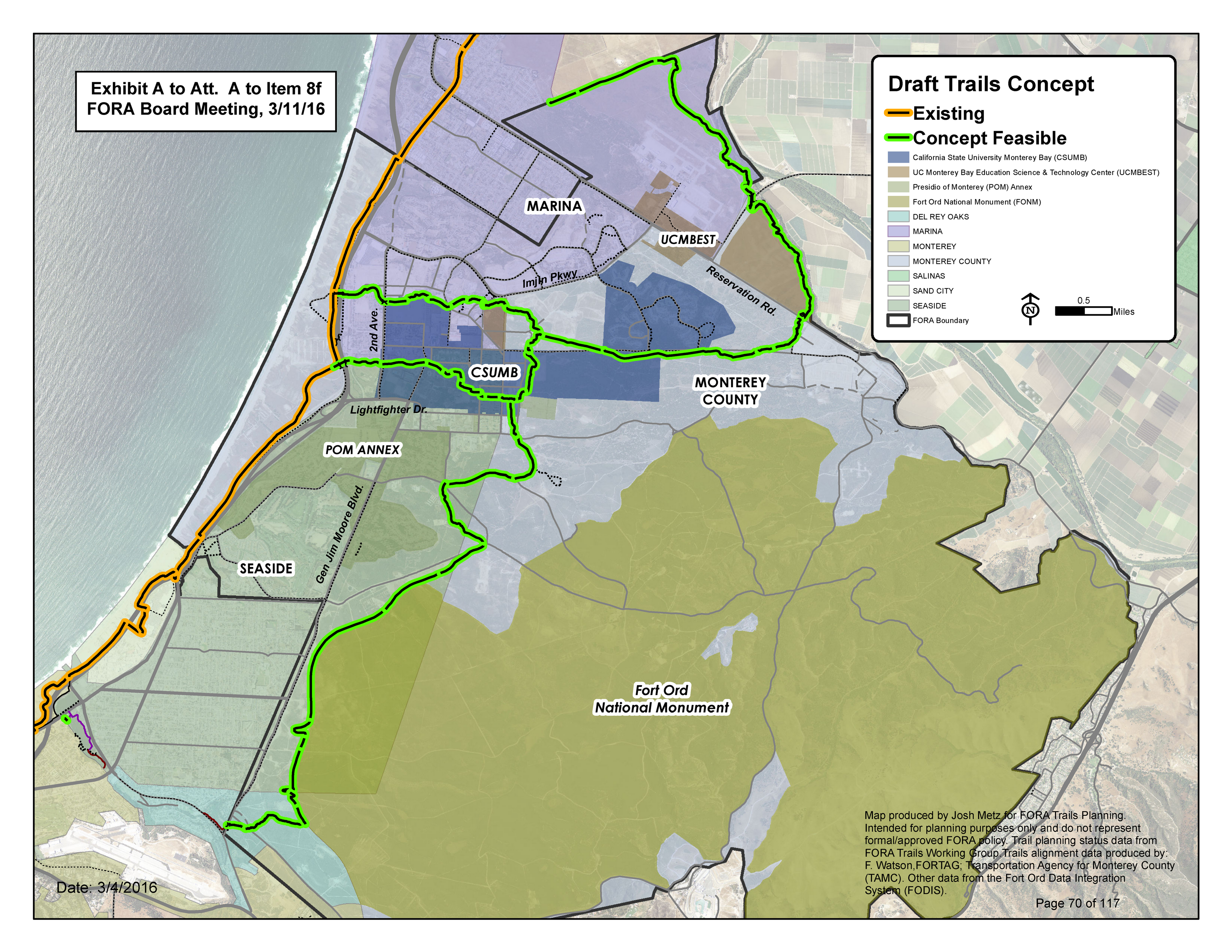
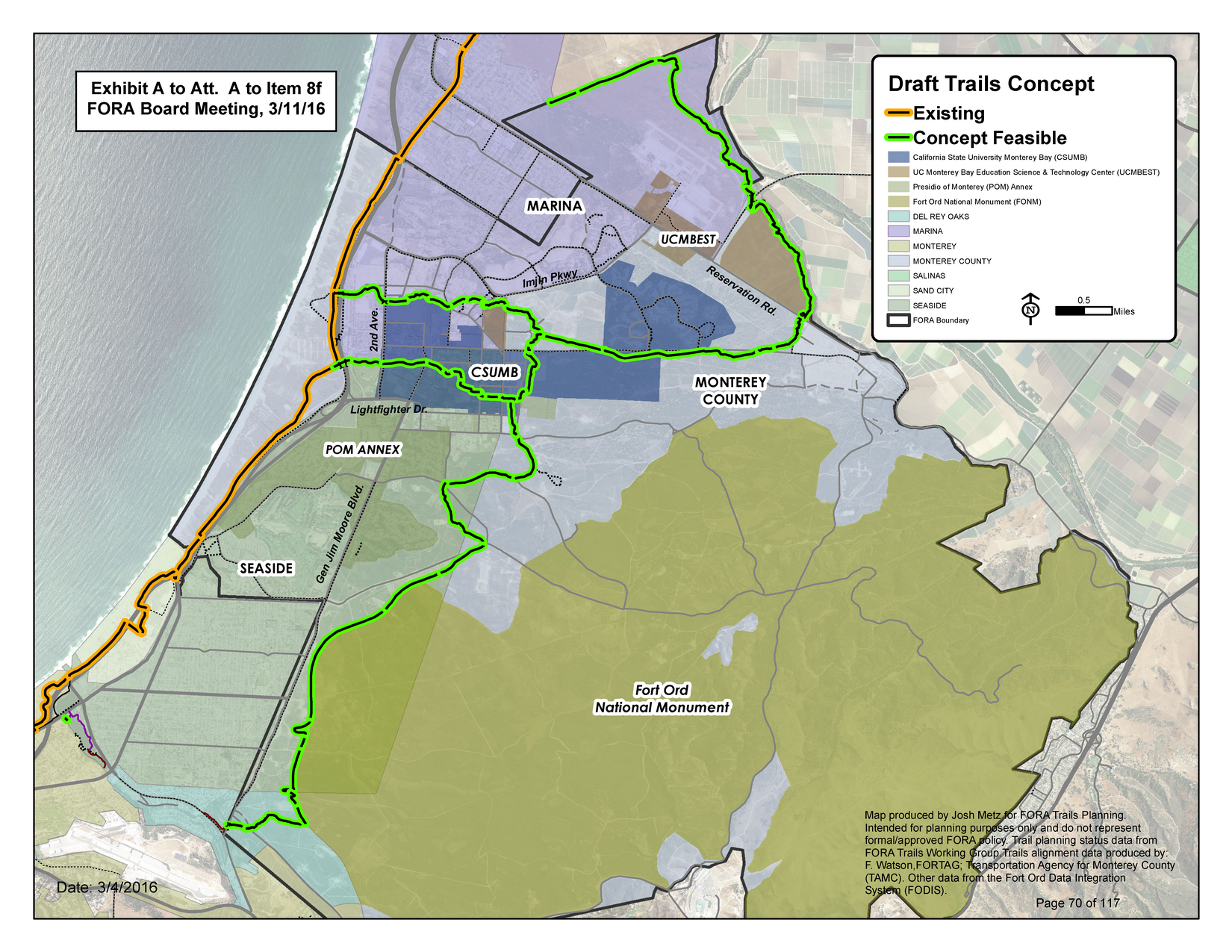
- 2016, Mar 11. FORA Board of Directors approves resolution supporting a "Draft Trails Concept" representing FORTAG, including the section through the eastern Frog Pond parcels.

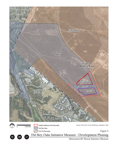
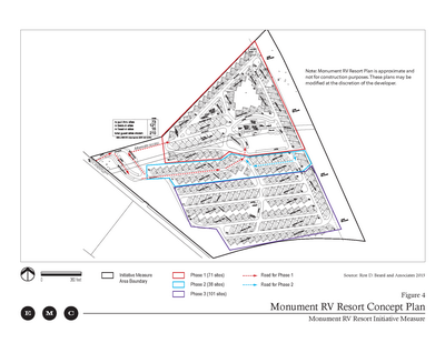
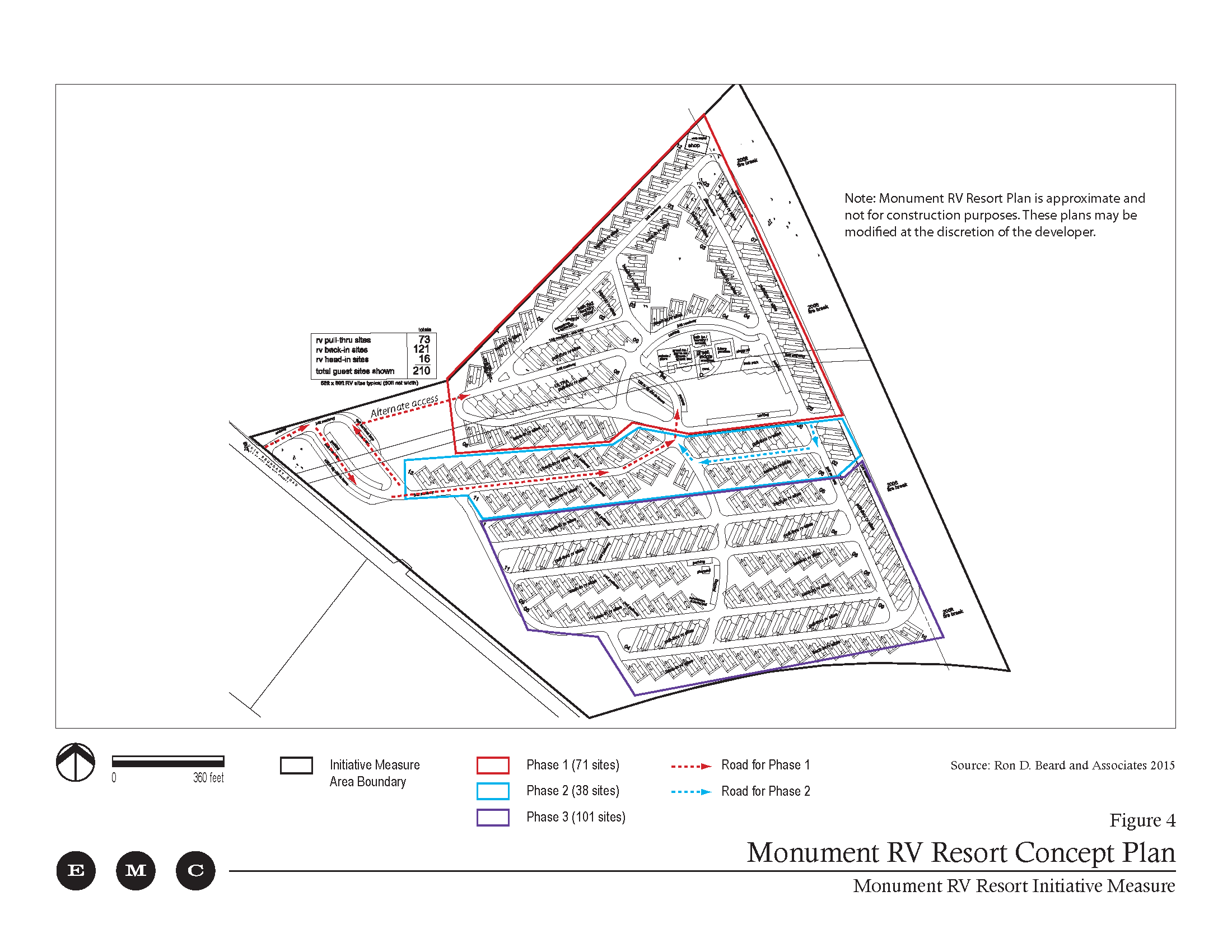
- 2016, May 24. City of Del Rey Oaks council adopted the Monument RV Resort Initiative Measure after receiving a petition with 174 valid signatures.
Links: (1) Measure, (2) Minutes.
- 2016, Oct. City of Monterey 2-pager soliciting developers for Fort Ord lands.
- 2016, Nov 30. County voters approve Measure X, which incudes a description and map of FORTAG, and $20M in funding for FORTAG.
- 2017, Mar 15. FORTAG meetig with MPRPD manager. Scott Waltz, Fred Watson, Rafael Payan, Todd Muck.
- 2017, Apr. 17. FORTAG meeting with DRO city manager. Scott Waltz, Fred Watson, Dino Pick.
- 2017, June 16. FORTAG meeting with DRO developers. Scott Waltz, Fred Watson, Sean Kranyak, Brad Slama.
- 2017, Sep 5. FORTAG meeting with FORA engineer about planned work at SBR & GJMB. Scott Waltz, Fred Watson, Peter Said.
- 2017, Sep 26. FORTAG meeting with MPRPD staff. Scott Waltz, Fred Watson, Tim Jensen.
- 2017, Sep. 29. FORTAG meetig with DRO city manager. Scott Waltz, Fred Watson, Dino Pick.
- 2017, Oct 11. Del Rey Oaks City Coucil approves MOU designating TAMC as Lead Agency for environmental review of FORTAG under CEQA.
- 2017, Oct 11. MPRPD Board of Directors approves Resolution 2017-10 in support of FORTAG, including an undercrossing of Gen. Jim Moore Blvd in so far as this relates to FORTAG alignments through MPRPD properties either side of GJMB.
- 2017, Dec 14. FORTAG site visit with DRO council member. Fred Watson, Rich Deal, Layne Buckley, Bryan Jones.
- 2018, Jan 8. FORTAG site visit with DRO council member. Scott Waltz, Fred Watson, Layne Buckley.
- 2018, Jan 18. FORTAG meetig with DRO city manager. Fred Watson, Dino Pick.
- 2018, Jan 19. FORTAG hike with DRO city manager. Fred Watson, Dino Pick.
- 2018, Feb 1. FORTAG meeting with FORA engineer about proposed work at SBR and GJMB. Scott Waltz, Fred Watson, Peter Said.
- 2018, Feb 8. FORTAG meeting with DRO council member and city manager. Scott Waltz, Fred Watson, Todd Muck, Rich Deal, Virginia Murillo, Dino Pick, Layne Buckley.
- 2018, Mar 8. Trails meeting with MPRPD manager. Fred Watson, Rafael Payan.
- 2018, Mar 12. FORTAG field trip. Fred Watson, Layne Buckley
- 2018 Mar 13. City of Del Rey Oaks council received two development proposals for the "17-acre site" along Hwy 218 east of GJMB. (Proposals rejected by council a year later on April 23 2019)
- 2018, Mar 27. FORTAG presentation to Del Rey Oaks City Council. Fred Watson.
- 2018, May 10. City of Monterey Site Opportunity and Feasibility Analysis for development of Fort Ord lands.
- 2018, May 17. Feasibility study of a regional trail underpass beneath General Jim Moore Boulevard in Del Rey Oaks, California. CSUMB class report. Conlen, Eichorn, Inglis, Watson. Demonstrates that there is enough vertical clearance to fit an underpass beneath GJMB. Visualizes what it would look like, using simulations based on site-specific topographic survey.
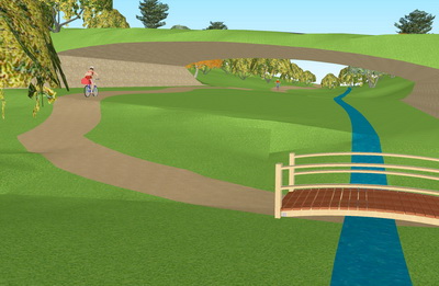
- 2018, May 20. CSUMB students complete feasibility study for the Gen. Jim Moore Blvd underpass near the Frog Pond.
- 2018, May 29. FORTAG meeting with DRO city manager. Fred Watson, Scott Waltz, Dino Pick, Rich Deal, Stefania Castillo.
- 2018, Dec 21. FORTAG meeting with DRO mayor & city manager. Fred Watson, Scott Waltz, Alison Kerr, Gary Kreeger, Dino Pick.
- 2019, Jan 30. FORTAG meeting with DRO mayor and city manager. Fred Watson, Alison Kerr, Dino Pick, Todd Muck, Rich Deal, Stefania Castillo.
- 2019, Feb 5. FORTAG public meeting at Del Rey Oaks City Hall.
- 2019, Feb 8. FORTAG phone meeting Audubon representative. Scott Waltz, Fred Watson, Chris Hartzell.
- 2019, Mar 3. FORTAG meeting with DRO resident. Fred Watson, Scott Waltz, Scott Donaldson.
- 2019, April 13. FORTAG "pop-up" event - Del Rey Oaks.
- 2019, April 18. FORTAG site visit to Frog Pond. Fred Watson, Scott Waltz, Rich Deal, Steve Frieson, Dino Pick.
- 2019, April 23. FORTAG & Hwy 218 presentation to Del Rey Oaks City Council. Rich Deal.
- 2019, April 23. City of Del Rey Oaks city council rejected the two development proposals they received a year ago on March 13 2018 for the "17-acre site" along Hwy 218 east of GJMB.
- 2019, April 25. FORTAG meeting about FORA SBR project. Rich Deal, Peter Said, Andy Hunter, Fernanda Roveri, Scott Waltz, Fred Watson.
- 2019, June 17. City of Monterey RFP for development of Fort Ord lands.
- 2019, Aug 23. FORTAG meeting with DRO resident and Audubon member. Fred Watson, Scott Waltz, Scott Hennessy, Rita Caratello, Don Gruber.
- 2019, Aug 30. FORTAG site visit to Frog Pond. Fred Watson, Scott Waltz, Allison Kerr, Don Roberson, Rita Caratello, Don Gruber, Scott Hennessy, Nikki Nedeff.
- 2019, Sep. 8. FORTAG site visit with DRO resident (and future MPRPD board member). Scott Waltz, Fred Watson, Kevin Raskoff.
- 2019, Sep 9. FORTAG site visit with MPRPD manager. Fred Watson, Scott Waltz, Rafael Payan.
- 2019, Sep 25. FORTAG meeting with DRO manager. Fred Watson, Scott Waltz, Dino Pick, Rich Deal.
- 2019, Sep 27. FORTAG meeting with DRO mayor and CSUMB students. Scott Waltz, Fred Watson, Alison Kerr, Laura Franklin, Eric Walmsley.
- 2019, Oct. 4. City of Del Rey Oaks RFP for development opportunity on Fort Ord lands.
- 2019, Oct/Nov. Draft Fort ord Habitat Conservation Plan released for public comment. FORTAG included.
- 2019, Nov 26. FORTAG DEIR Presentation to City of Del Rey Oaks, by TAMC staff.
- 2019, Dec 8. FORTAG tour for Audubon board members. Fred Watson, Shawn Wagoner, Robert Horn, Jan Scott, Amanda Preece.
- 2019, Dec 18. FORTAG site visit to Frog Pond. Scott Waltz, Fred Watson, Rafael Payan, Rich Deal, Stefania Castillo
- 2020, Jan 8. This web page presented to MPRPD board meeting in open public comment & via email.
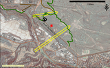
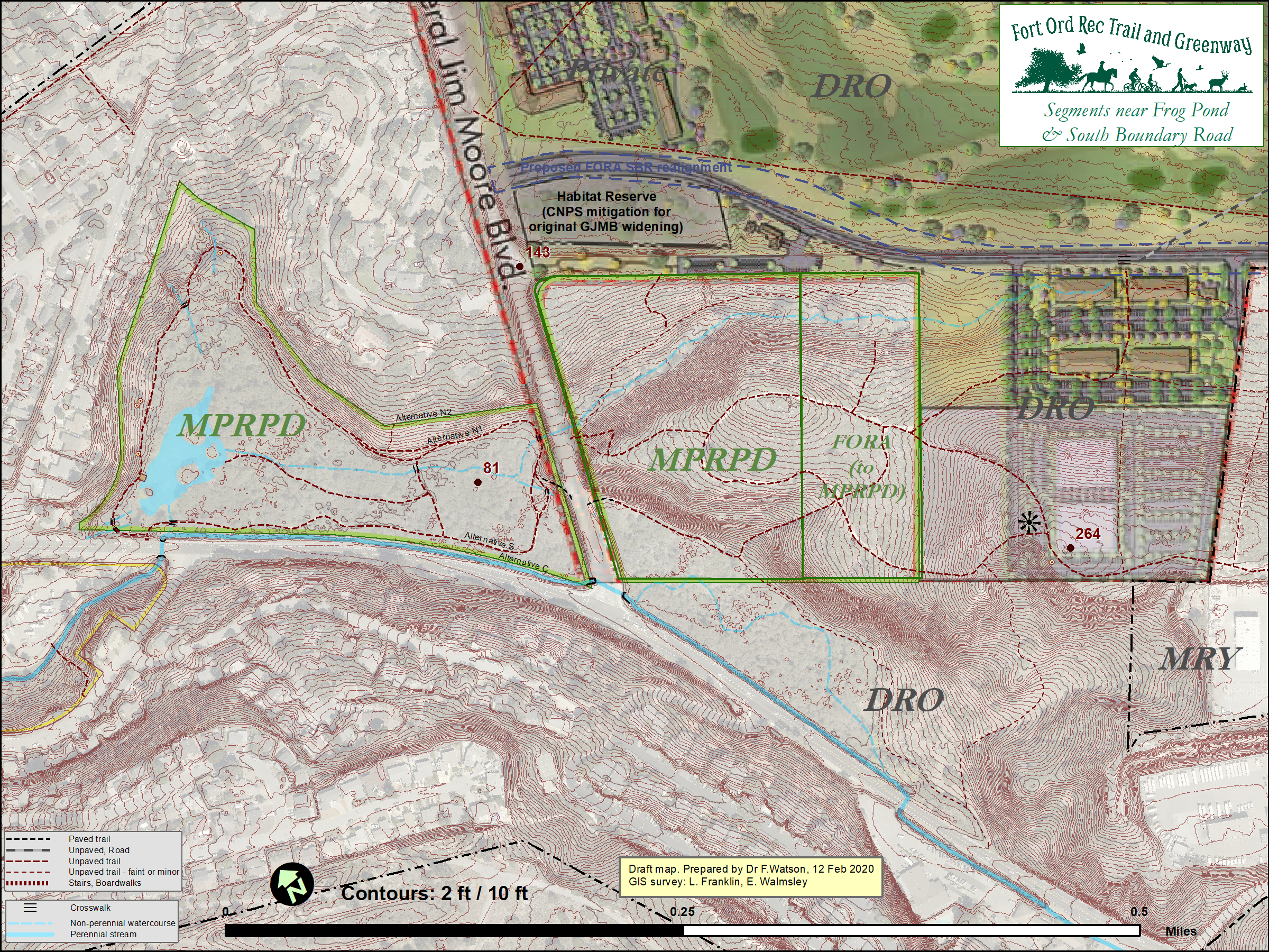
- 2020, Feb 12. FORTAG study session about Frog Pond - MPRPD Board of Directors - Including Presentation to the Board
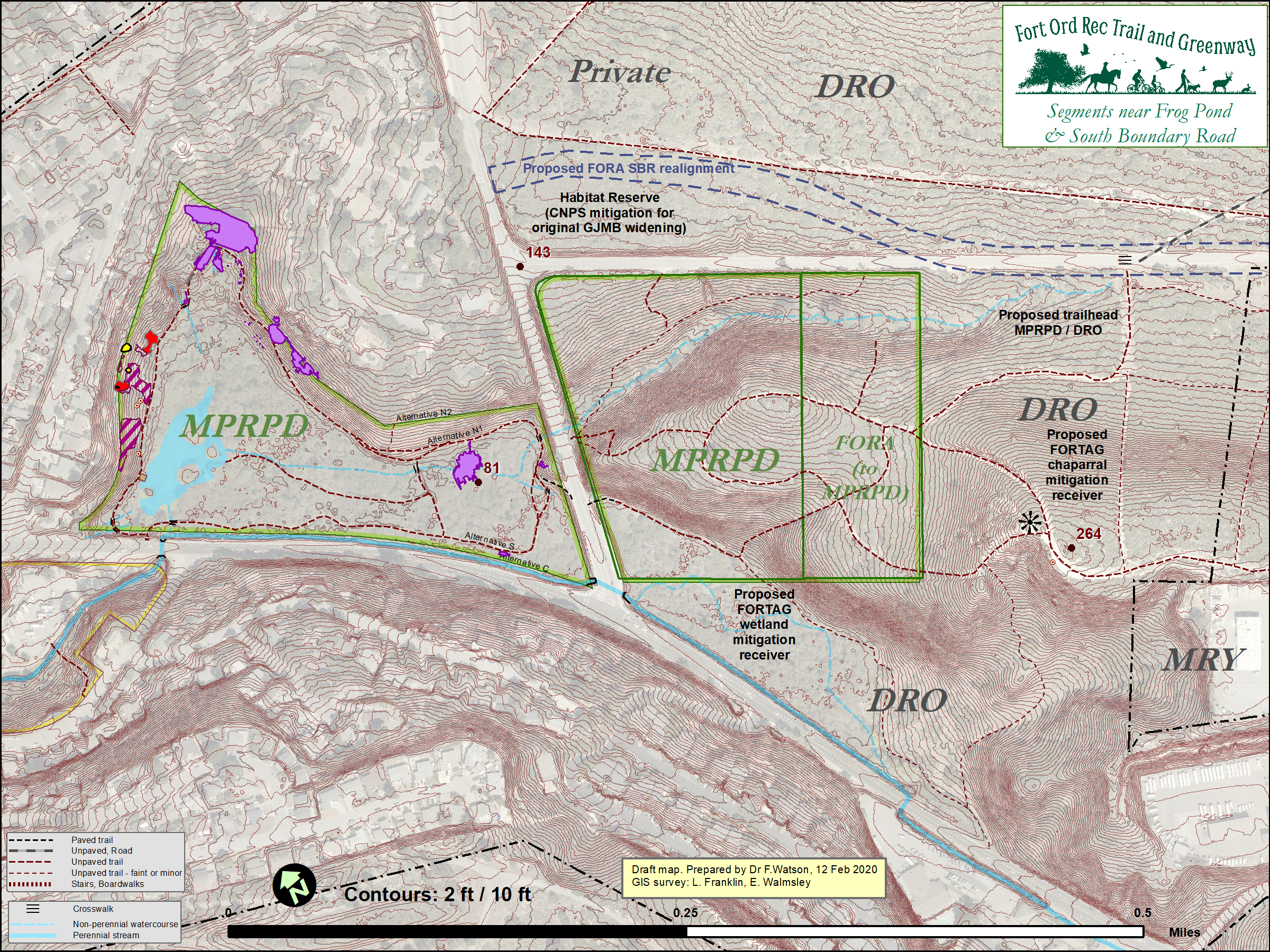
Early version of an integrated conceptual plan for Frog Pond expansion and trailhead (since revised)
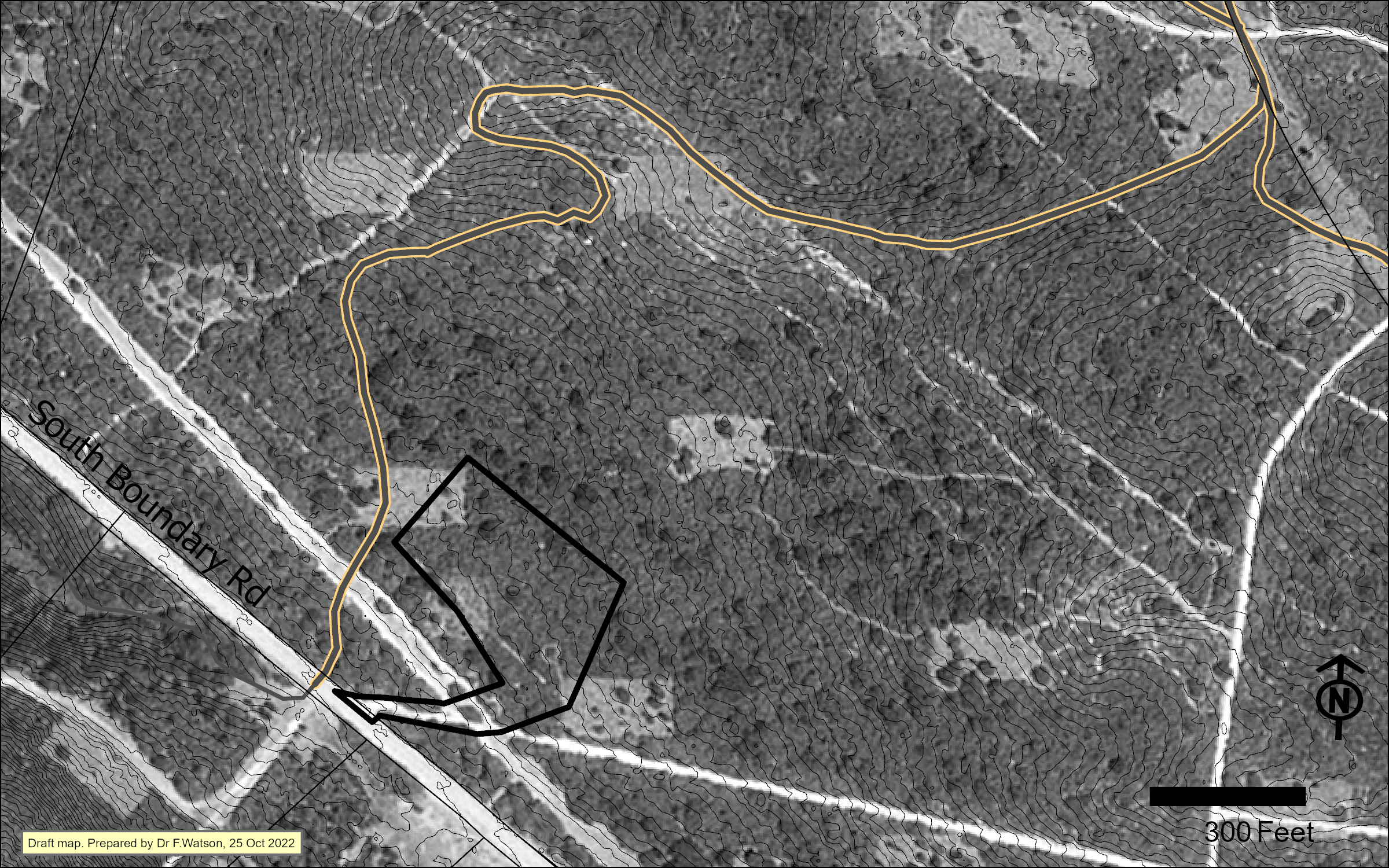
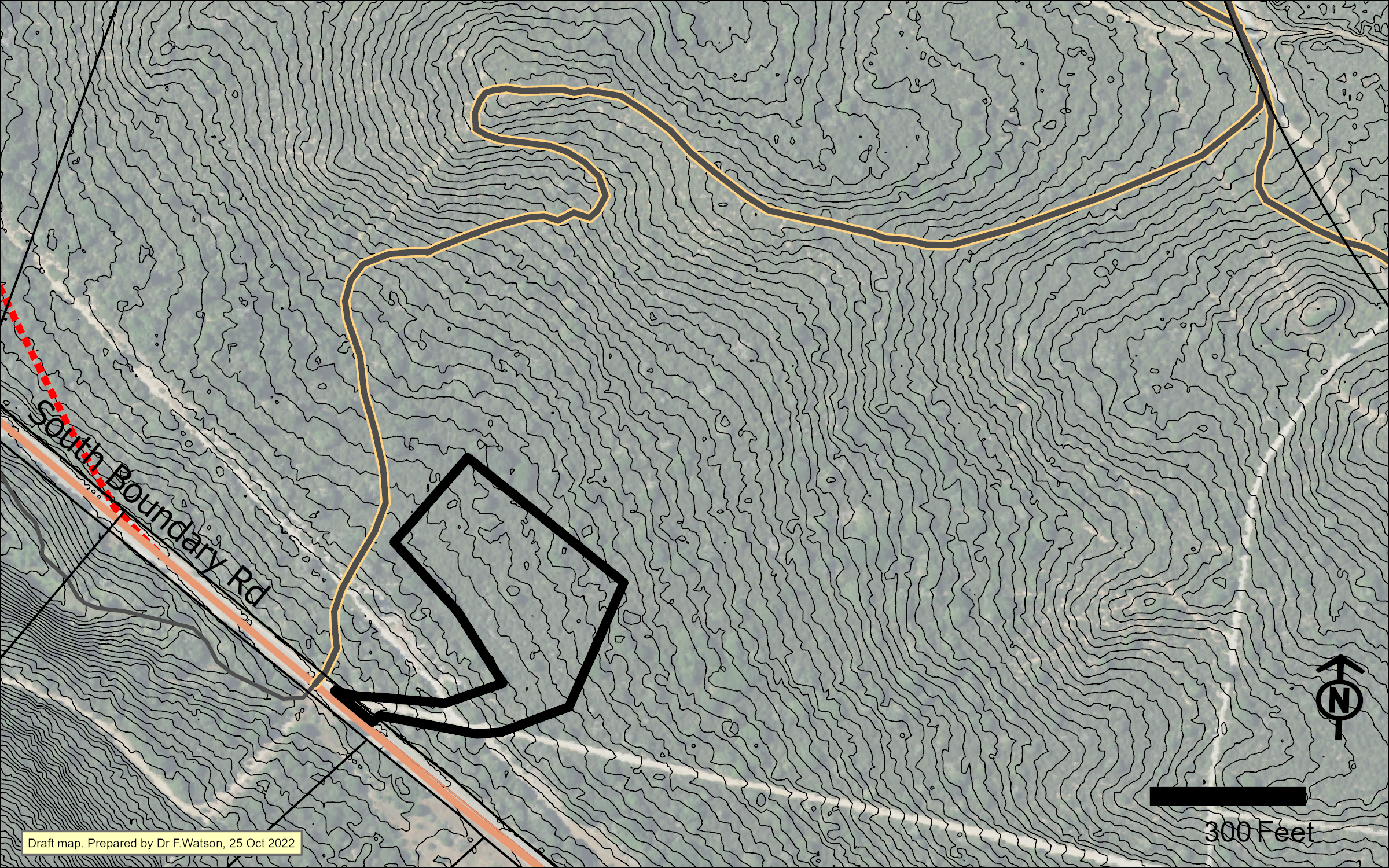
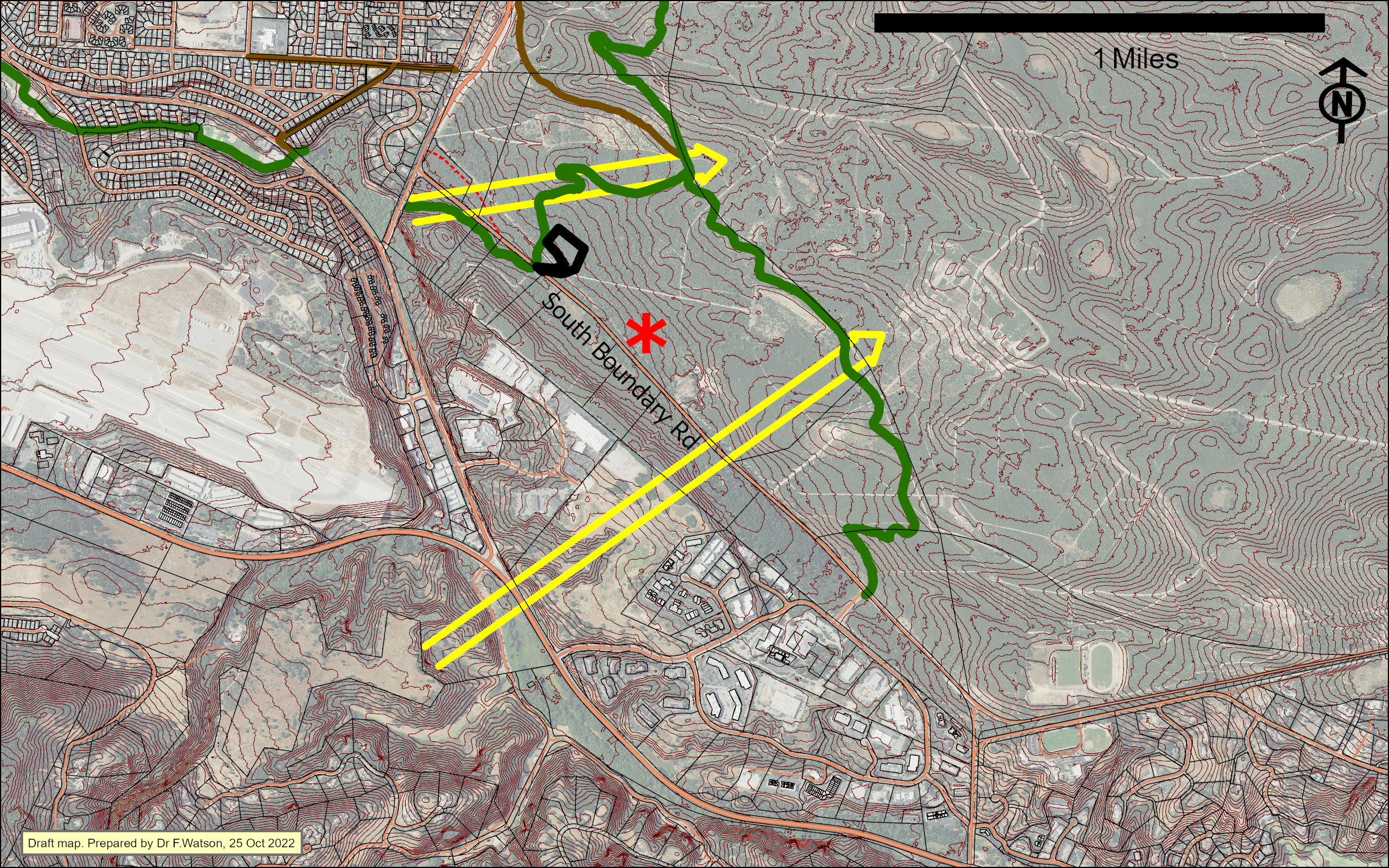
- 2022, Oct 24. Temporary pavement recycling facility proposed for a site north of South Boundary Road.
- Council agenda item
- Location in relation to proposed FORTAG route
1998 aerial image
Recent aerial image
Wide view
- 2022, Nov 15. DRO City Council agreed to surplus all city land in and near the former Fort Ord.
- 2022, Dec 13. DRO City Council amended APNs for land surplus agreed at previous meeting.
- 2023, Feb 2. DRO. Date of "Notice of Availability/Offer to Sell Surplus Property"
- 2023, March. Various maps relevant to the surplus action
- 1862. Probable commencement of cattle grazing at Frog Pond after patent granted for Rancho Noche Buena.


